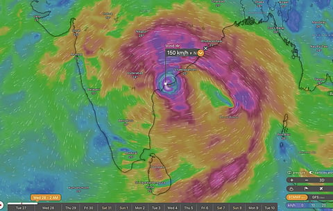


Cyclone Arnab is expected to make landfall along the Andhra Pradesh coast on October 28 as a very severe cyclonic storm, with wind gusts reaching 150 km/h.
Weather models indicate that another cyclonic system could develop over the Bay of Bengal and approach the Odisha coast in the coming days.
A low-pressure area over the southwest Bay of Bengal weakened on October 27, but experts suggest a fresh system could form shortly after Arnab.
Forecasts differ on the timing and path of a possible second cyclone, with weather experts cautioning that its formation remains uncertain.
The India Meteorological Department is continuously monitoring Cyclone Arnab, with further updates expected to provide greater clarity.
Cyclone Arnab is still making its way towards the Andhra Pradesh coast, but the Bay of Bengal could already be brewing another storm. Weather models suggest a second cyclone may develop and head towards Odisha within days of Arnab's expected landfall on October 28, although experts warn that the forecasts remain uncertain.
Two weather systems were active over the Bay of Bengal on October 27, with very severe cyclonic storm Arnab approaching Andhra Pradesh and another low-pressure area over the southwest Bay of Bengal.
While some weather models indicated that the second system could intensify and approach the Odisha coast, experts cautioned against drawing firm conclusions from the forecasts.
Cyclone Arnab moved westwards at 22 kilometres per hour (km/h) during the six hours overnight between October 26 and 27, According to the latest update from the India Meteorological Department (IMD).
The storm underwent rapid intensification, with wind speeds increasing by 74 km/h in the 24 hours between the mornings of October 26 and 27. The storm reached peak intensity with sustained winds of 150–160 km/h, gusting to 180 km/h. However, the IMD forecast that it could weaken before making landfall.
The storm was located approximately 140 km southeast of Kakinada and 170 km south of Vishakhapatnam at 2.30 pm on October 27, according to IMD.
According to the IMD's latest update on X (formerly Twitter), Cyclone Arnab is expected to move west-northwestwards until the evening of October 27 before turning northwestwards and crossing the Andhra Pradesh and Yanam coasts between Bapatla and Visakhapatnam, near Yanam, before noon on October 28.
The storm is forecast to make landfall as a very severe cyclonic storm, with maximum sustained wind speeds of 125–135 km/h, gusting to 150 km/h, the IMD said.
The United States Navy's Joint Typhoon Warning Center (JTWC) has estimated substantially higher wind speeds for Cyclone Arnab than those reported by IMD.
According to the JTWC's cyclone advisory, Arnab had sustained winds of 115 knots (213 km/h), with gusts reaching 140 knots (259 km/h).
The agency also forecast that the cyclone could strengthen further, with peak sustained winds reaching 120 knots (222 km/h) and gusts of up to 145 knots (269km/h). These estimates are considerably higher than the IMD's reported peak sustained winds of 150–160 km/h, gusting to 180 km/h.
In a press release on October 26, the IMD reported another low-pressure area over the southwest Bay of Bengal and adjoining coastal Tamil Nadu. However, its tropical weather outlook did not indicate whether the system was expected to intensify further.
Weather blog Vagaries of Weather told Down To Earth (DTE) that the low-pressure area had weakened by the morning of October 27 and could dissipate.
Meanwhile, forecasts from the European Centre for Medium-Range Weather Forecasts (ECMWF), visualised on the Windy weather platform, suggested that the system could move around cyclone Arnab, intensify and cross the coast near the Andhra Pradesh-Odisha border on the evening of October 28. However, such projections could be misleading given the complexity of the weather conditions.
The ECMWF model, as displayed on Windy, had also indicated an earlier landfall for cyclone Arnab, during the night of October 26-27.
Vagaries of Weather told DTE about a different possibility: a fresh low-pressure area could form over the southeast Bay of Bengal shortly after cyclone Arnab and approach the Odisha coast around November 1-2.
Several forecasting models, including the IMD's Global Forecast System (GFS), ECMWF and Bharat Forecasting System (BFS), indicated the possibility of this new system developing into a cyclone, according to the Vagaries of Weather.
The forecasts, however, remain uncertain, and the formation of another cyclone has not been confirmed.
The IMD said cyclone Arnab was being continuously monitored by Doppler weather radar in Visakhapatnam. Further updates from the agency could provide greater clarity on the storm's movement and the possibility of another developing system.