
Subscribe

A low-pressure area formed over southwest and adjoining west central Bay of Bengal in the early morning hours of May 22, 2024, according to the latest update from India Meteorological Department (IMD).
The weather agency said the storm system is likely to move northeast and intensify into a depression by the morning of May 24.
After that, the depression may continue moving in the same direction, intensify further and reach the northeast and adjoining northwest Bay of Bengal by the evening of May 25, according to IMD.
IMD has not yet mentioned anything about the system strengthening into the season’s first cyclone, which would be named Remal.
The Joint Typhoon Warning Centre (JTWC) of the United States Navy also issued an alert for a depression in the Bay of Bengal. The JTWC highlighted favourable environmental conditions for the system’s intensification, such as warm sea-surface temperatures of 28-29 degrees Celsius and low vertical wind shear, and stated all global weather models agree with this assessment.
Warm sea-surface temperatures provide the necessary heat and moisture for the storm system to grow and low vertical wind shear, which are upwardly mobile winds in the vicinity of a cyclone, would not disrupt the top structure of the cyclone leading to its dissipation.
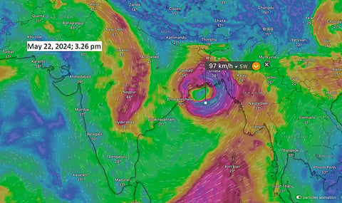
The weather analysis and visualisation platform Windy.com also currently shows the formation of a low-pressure area just off the coast of Tamil Nadu.
The platform’s forecast, based on data from the US Global Forecasting System (GFS), showed the formation of cyclone Remal on May 26 morning in the northwest Bay of Bengal. It further indicated that the cyclone may move close to the coasts of West Bengal and Bangladesh.
The weather tracking and analysis website The Weather Channel (TWC) also put out an alert regarding cyclone Remal.
“There's a consensus that a cyclonic storm is more likely than a more intense system. The Weather Channel’s meteorological team suggests the possibility of a cyclone forming, but the chances of it intensifying into a severe or very severe cyclonic storm are slim,” TWC wrote on its website.
In recent years, forecasting cyclones has been challenging due to increasing unpredictability in sea-surface temperatures, especially below the surface and the behaviour of winds around the cyclone.
Regarding the potential impacts of the cyclone, the IMD stated there would be light to moderate rainfall in many places, with isolated heavy rainfall over North and South 24 Parganas and Purba Medinipur districts of West Bengal and Balasore district of Odisha on May 25 and 26.
IMD has made a similar prediction for Mizoram, Tripura and south Manipur for the same dates. TWC forecasts 200 millimetres or higher rainfall totals for Assam, Meghalaya, Manipur, Mizoram and Tripura from May 26-28.