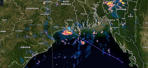

The India Meteorological Department (IMD) is tracking a low-pressure area off the coast of West Bengal that formed on the morning of September 28, 2021. It had slightly intensified to a well-marked low-pressure area by afternoon.
This, even as Cyclone Gulab’s remnant low-pressure area is traversing Maharashtra, causing heavy rainfall.
The Global Forecasting System data, as represented by the website Earth Null School, showed that the system might intensify further over land, forming an extremely rare ‘land cyclone’.
The IMD has not yet generated an alert for such cyclone formation. It said in its latest release that the system might not intensify further, according to models.
The IMD has predicted heavy to extremely heavy rainfall for West Bengal, Odisha and Jharkhand. West Bengal has been put on red alert for September 28.
The Joint Typhoon Warning Centre (JTWC) of the United States Navy, on the other hand, found the conditions around the West Bengal coast to be suitable for further intensification.
The JTWC said:
The environment is favourable for development, with an anticyclone aloft just to the northeast, providing good radial outflow and low vertical wind shear. Sea surface temperatures remain very warm, while the system is currently Moving onshore, it will do so over a region of swampy ground in a river delta.
It added: “Thus, intensification over land is a distinct possibility. Formation of a significant tropical cyclone is possible.”
The cyclone, if it does form over land, would be the fifteenth land cyclone ever recorded. It has happened only 14 times since 1891 and only twice since 1975, according to data from the IMD.
The remnant of Cyclone Gulab, in the form of a low-pressure area, currently lies over the Vidarbha region of Maharashtra, according to IMD.
If the remnant of Cyclone Gulab crosses over to the Arabian Sea on September 30 and subsequently re-intensifies into a cyclone, it would be first time in the last four decades such an event would happen.
The cyclone that forms from the remnant of Cyclone Gulab and the new cyclone over West Bengal would be competing for the name ‘Shaheen’ (‘Peregrine Falcon’ in Persian). The naming would be done based on the time of formation.
The other cyclone would be named ‘Jawad’ (‘Generous’ in Arabic). Both cyclones would be the rarest of rare occurrences.
Roxy Mathew Koll, a climate scientist at the Indian Institute of Tropical Meteorology, Pune, said:
A cyclone crossing over the land from the Bay of Bengal and re-emerging in the Arabian Sea again as a cyclone does not happen often. In 2018, Cyclone Gaja did cross over from the Bay of Bengal to the Arabian Sea, but this was not considered as a cyclone in the Arabian Sea (according to IMD records).
“It is not totally unusual for cyclones to cross over India into the Arabian Sea,” Raghu Murtugudde, a climate scientist at the University of Maryland, United States, said.
They tend to happen over Peninsular India more often because the land extent is small but then, they have to get over the Western Ghats.
“This one is going a little bit northwestward and hugging the Pakistani coast and maybe enter the Gulf of Oman onto land,” Murtugudde said.
“Generally, the monsoon conditions are not favourable for cyclones to develop in the north Indian Ocean,” Koll said.
This is because of the strong opposing winds in this region — the lower atmospheric winds are in one direction (southwesterly) and the upper atmospheric winds are in the other direction (northeasterly).
This prevents a cyclone from developing vertically.
However, multiple factors, including warmer ocean conditions, are now assisting cyclone formation during the onset and withdrawal time, when the monsoon is not at its peak, according to him.
In fact, both Cyclone Tauktae in the Arabian Sea and Cyclone Yaas in the Bay of Bengal formed in the pre-monsoon period and in quick succession.
Cyclone Tauktae, like Cyclone Gulab, had also travelled a long distance over ocean and land to cause rainfall in Delhi. It had brought the city’s temperature down by a whopping 16 degree Celsius in the middle of May.
It had remained a cyclone for almost 18 hours after landfall. It was also only the third May cyclone to make landfall in Gujarat.
In the case of Cyclone Gulab, Koll said the remnants of the cyclone (the rotational element) in the South China Sea came to the Bay of Bengal. In the Bay of Bengal, the ocean-atmospheric conditions were favourable for the cyclone to re-emerge again, as Cyclone Gulab.
Now, Gulab has weakened as it crosses land (since heat and moisture from the ocean is cut-off). But as it reaches the Arabian Sea, which is warm and humid, the possibility of it re-emerging as a cyclone again rises.
“Since depressions seek energy, it is finding enough moisture and weak vertical shear along this path. We have to wait and see how accurate the forecasts are but conditions seem to be favourable for the cross-country trek,” Murtugudde said.
Murtugudde added that the Arctic ice loss this summer, brought excess rainfall in the form of a series of low- pressures areas that formed in the Bay of Bengal in September.
These may have created enough moisture to feed the depression to stay alive across the land track. The new cyclone that might form over West Bengal, might also be fed by the same excess moisture.