
Subscribe

An unusual storm has taken form over the Bay of Bengal, which can turn into a possible cyclone. It is not common to have cyclonic storms before the monsoon season is over.
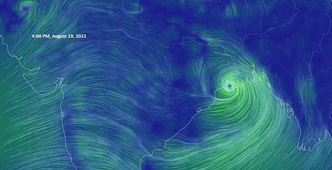
The storm is also unusually positioned more north, according to Skymet Weather. The company provides weather forecasting services. Storms usually move towards Odisha while this one is expected to affect West Bengal more.
A depression over the Bay of Bengal intensified into a deep depression August 19, 2022, according to the India Meteorological Department’s (IMD) Bhubaneswar centre. However, the Joint Typhoon Warning Center has announced a warning for a tropical cyclone 4B.
Strong winds are expected over the coast of West Bengal and adjoining Odisha. This will give heavy rains over parts of east India, which have been waiting for some rains. Weather in West Bengal, Jharkhand, Odisha and Chhattisgarh will be affected for the next 24 hours.
A low-pressure area had formed in the area August 18, which is now moving west-northwest, according to the IMD.
The depression was close to Balasore in Odisha coast and Digha and Sagar Islands in West Bengal and is expected to cross between these areas August 19 evening.
The sea condition is likely to be rough to very rough over north Bay of Bengal and along and off West Bengal, Odisha and Bangladesh coasts until 11 AM Indian Standard Time August 20, according to IMD.
If the depression continues to move in the same direction, it will cross West Bengal, north Odisha, Jharkhand and north Chhattisgarh after landfall and weaken gradually. Landfall is when a storm moves to land after being over water.
Surface winds are expected to reach the speed of 55-65 kilometres per hour, going up to 75 kmph, IMD said.
A red alert had been sounded for all Odisha ports, the Press Information Bureau for Bhubaneswar had tweeted. Warnings for Mayurbhanj, Baleshwar and Bhadrak were also issued.