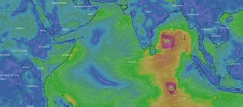

A cyclonic circulation is likely to form over the southeast Bay of Bengal on May 6, 2023, according to the India Meteorological Department (IMD).
Under the influence of cyclonic circulation — swirling winds — a low-pressure area will likely develop over the same region on May 7, IMD noted. In the next 48 hours, the system will likely concentrate into a depression, where wind speeds range from 32-52 kilometres per hour (kmph).
Conditions are conducive to the formation of cyclones in the Bay of Bengal. The tropical cyclone’s heat potential over the southeast and central Bay of Bengal is 100 kilojoules per square cm (KJ/cm2). The sea surface temperature over the entire Bay of Bengal is 30-32 degrees Celsius.
“Cyclogenesis is favoured by the warm sea surface temperatures (SST), so we have to see how the depression intensifies,” Raghu Murtugudde, a climate scientist at the University of Maryland and Indian Institute of Technology, Bombay, previously told Down To Earth.
IMD-Global Forecast System (GFS) model predicted a low-pressure area over the southeast Bay of Bengal on May 6, which will intensify into a cyclonic storm on May 9 near the Andaman Islands. GFS is a National Centers for Environmental Prediction (NCEP) weather forecast model.
The storm will move north-northeastwards towards the east-central Bay of Bengal till May 11, skirting the Andaman Islands.
The Global Ensemble Forecast System (GEFS), another weather model created by NCEP, predicted a low-pressure area forming on May 7 and a depression on May 9.
Also, the European Centre for Medium-Range Weather Forecast (ECMWF) suggests that a low-pressure area will form over the south Andaman Sea on May 8 or 9. By May 10, a depression will likely develop in the south Andaman Sea and the southeast Bay of Bengal. A cyclonic storm is predicted to form on May 11.
The system will move north-northeastwards and intensify into a cyclonic storm near the Andaman Islands, according to ECMWF. Both ECMWF and GCF have predicted a severe cyclonic storm to take hold in the region.
Further, GCF data, as visualised by the software Windy, showed that wind speeds could reach 62 kmph on May 8. It also indicated another depression could be brewing in the Indian Ocean, with speeds reaching 52 kmph. By May 10, wind speeds could reach 72 kmph over the southeast Bay of Bengal and 70 kmph in the Indian Ocean.