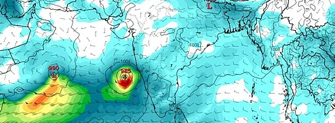

The southwest monsoon will get a boost in its advance over India due to a low-pressure area forecast to form in the Arabian Sea in the first week of June (May 31-June 4, 2020), according to the India Meteorological Department (IMD).
The monsoon winds have already advanced into the Maldives-Comorin area, some parts of south Bay of Bengal, the Andaman Sea and the Andaman and Nicobar islands, IMD said.
The conditions for the onset of the monsoon season over Kerala will become favourable from June 1, the IMD said. But it did not give a date for the onset. It had earlier predicted a delay of four days in the onset of the monsoon over Kerala.
“The anti clockwise winds of the low pressure area might pull the monsoon trough towards India, making conditions favourable for the onset,” Raghu Murtugudde, climate scientist at the University of Maryland, said. But there is a caveat.
“The delay in the monsoon and the lack of vertical shear (change in winds with height from the surface) allows the cyclone to grow. If the monsoon would arrive, it would suppress the cyclone. But we will have to watch carefully where the monsoon trough is by the time cyclone forms,” he added.
“The direction of the winds around a low pressure system in the northern hemisphere is always cyclonic (anti-clockwise). This is because of the rotation of the earth. It is the track of the system that determines whether the Indian subcontinent will receive the rains or not,” Roxy Matthew Koll, a climate scientist at the Indian Institute of Tropical Meteorology, said.
“So if the low pressure system moves away from the mainland, the subcontinent may not receive much rains during the onset. However, the updated IMD forecasts indicate that the low pressure system may recurve back to India. If that happens, it will bring in more rains and also pull the monsoon into the subscontinent,” he added.
The European Centre for Medium-Range Weather Forecasts has also predicted that the low pressure that will form over the Arabian Sea off the coast of Kerala, will intensify further into a cyclonic storm and move towards the India-Pakistan coasts.
Data from the Global Forecasting System of the United States does not indicate any such formation as of May 28, 2020.
Another low pressure area in the west central Arabian Sea has already formed. This will intensify into a depression in the next two days and move towards the South Oman and East Yemen coasts thereafter, the IMD has predicted.
The formation of low pressure areas usually indicates warm sea surface waters.
Bad memories of Vayu
Last year, a cyclone just after the onset of the monsoon, had made progression of the monsoon difficult over the Indian mainland. Cyclone Vayu had formed as a low pressure area on June 9, 2019, just after the onset of the monsoon over Kerala on June 8.
The monsoon winds were not able to move forward till the dissipation of the cyclone on June 17 and the rains were arrested in Kerala, Karnataka and Tamil Nadu.
The scanty rain scenario changed in the last week of June when some regions started receiving intermittent rainfall. Due to this, the rain deficit figure dropped to 33 per cent by June-end and 28 per cent by July 3.
The first heavy spell of rains began around July 7. Up until then, rainfall deficiency was 40 per cent or more in 266 districts. For nearly half of them, the deficiency was greater than 60 per cent; in 46 districts it had exceeded 80 per cent.
After this, the monsoon did not stop and ended up being the most intense in the past 25 years. Countrywide rainfall excess was at 9 per cent above normal during the entire season.
The season was also unusually long, with the withdrawal of the monsoon beginning only October 9, almost 40 days late. Once the withdrawal began, the winds retreated quickly and the monsoon withdrew completely from the Indian Subcontinent in a week, a process that usually takes a month.