Earthquake catalogues in other world regions often do not go as far back into the past as in Britain and Ireland
 Britain experiences hundreds of earthquakes each year. Photo: Raffaele Bonadio, Author provided
 The village of Tean in Staffordshire, England, was hit by a 3.3-magnitude earthquake on June 28 2023. The tremors caused windows and doors to rattle in the surrounding area.
Earthquakes of this nature are not uncommon in Britain (the island including England, Scotland and Wales). In fact, hundreds of earthquakes shake Britain every single year.
The majority of these earthquakes are small in magnitude and do not result in any damage. However, there are occasional earthquakes in Britain that have the potential to be destructive. Scientists estimate that the largest possible earthquake in Britain is around a magnitude 6.5 – surpassing the intensity of the magnitude 6.3 earthquake that hit Christchurch, New Zealand in 2011 and killed 185 people.
The largest recorded earthquake in Britain so far took place in 1931 near Dogger Bank, 97km off the east coast of England. This earthquake measured 6.1 on the Richter scale and caused damage to buildings along the east coast.
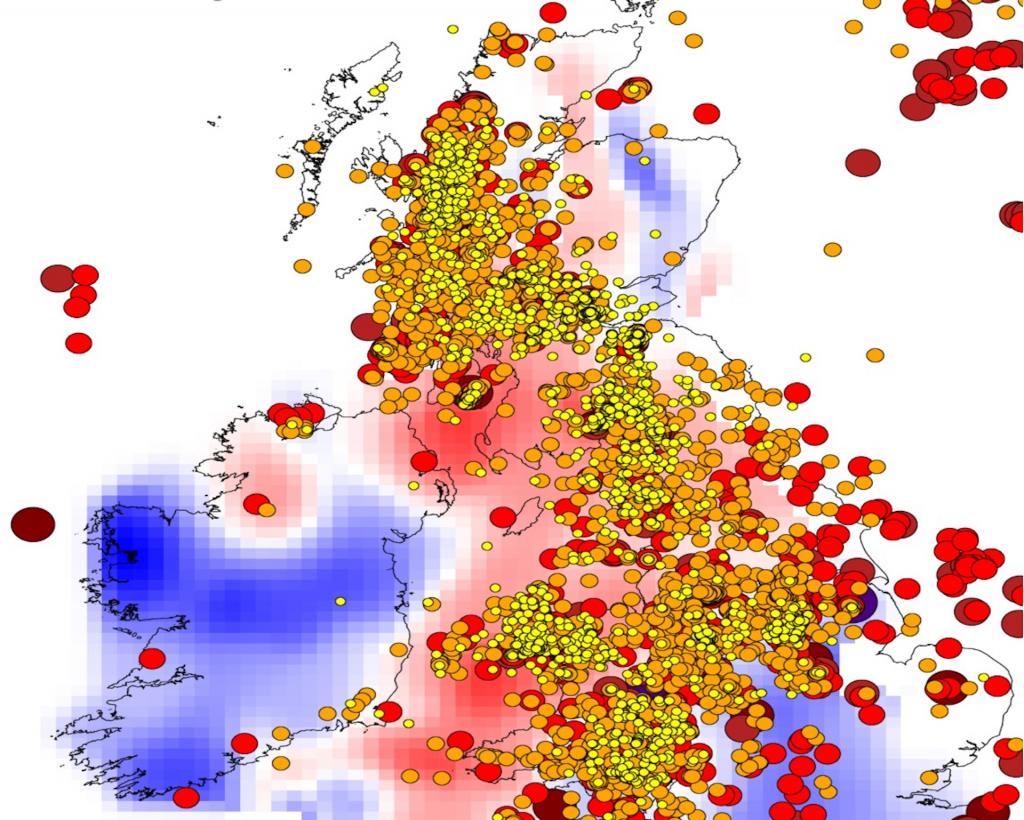
Most earthquakes in Britain are concentrated within a north-to-south band on the west side of the island. Neighbouring Ireland, however, is almost completely free from seismic activity – a phenomenon that has puzzled scientists for hundreds of years.
Research by my colleagues and I has provided a potential explanation for Ireland’s minimal seismic activity. We found that the lithosphere – Earth’s rigid outer layer that makes up its tectonic plates – is thicker and cooler beneath Ireland than it is under Britain. This makes the tectonic plate under Ireland much less likely to deform – a process that can trigger earthquakes.
Even before earthquakes were recorded by seismographs as they are today, reports of earthquakes were documented in various towns and monasteries across Britain and Ireland. In the mid-19th century, Robert Mallet, an Irish scientist credited with coining the term “seismology”, created earthquake maps based on these reports. He observed that Britain had intermediate seismicity (a term for earthquake activity), while Ireland had low seismicity.
In 1884, Irish seismologist Joseph O’Reilly published the first seismicity map of Britain and Ireland, emphasising that Great Britain was “by far more subject to earthquake action than Ireland”.
Understanding the reasons behind this uneven distribution remains important today, especially in terms of how it affects Britain’s growing population. Between 2011 and 2021, the UK population increased by 6 per cent, to a total of 67 million people.

Most earthquakes happen at plate boundaries where tectonic plates converge, diverge or slide past each other. Over 80 per cent of the world’s largest quakes occur around the perimeter of the Pacific Ocean – an area known as the Pacific “Ring of Fire”.
Earthquakes that occur in the interior of the plates are much less common and typically smaller in magnitude. But there are a few notable exceptions. Between 1811 and 1812, the New Madrid Seismic Zone in the central US experienced a sequence of powerful earthquakes, ranging from magnitude 7 to 8.
Britain and Ireland are geologically very similar. They were formed in the same continental collision around 400 million years ago and are composed of parts of the same continents. The two islands are also equally far from plate boundaries and the tectonic stress (the pressure or tension exerted by other plates or underlying mantle) is similar across them.
Why then is the distribution of earthquakes in Britain and Ireland so uneven?
Seismic tomography, a technique that uses seismic waves from remote earthquakes to create 3D images of Earth’s interior, has provided valuable insights. Research that I co-authored in 2021 discovered previously unknown variations in the structure of the tectonic plate that both Britain and Ireland sit on.
Tectonic plates are cold and rigid compared to the hot, slowly creeping mantle beneath them. Thicker plates are colder, mechanically stronger and less likely to deform. Conversely, thinner plates are warmer, weaker and more susceptible to deformation.
In our more recent research, we found that that the plate thickness below Britain and Ireland ranges from about 75km to as much as 120km. Ireland has a relatively thick lithosphere (around 95-115km beneath most of the island) and very few earthquakes as a result. South-eastern England and eastern Scotland have a similarly thick lithosphere.
By contrast, western Britain has a thinner lithosphere (around 75–85km) and experiences regular earthquakes. Most Irish earthquakes are in the north of the island, the one place where its lithosphere is thinner, warmer and weaker.
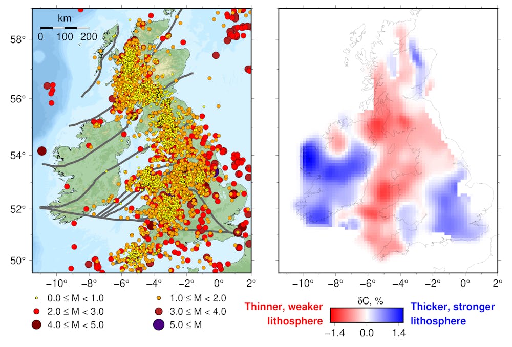
This discovery solves a longstanding puzzle. Moderate variations in plate thickness, occurring far from plate boundaries, can influence patterns of seismic activity within those regions.
This breakthrough opens up new avenues of research for seismologists. In Britain and Ireland, scientists can now focus on closing the remaining gaps in the coverage of seismic stations (which monitor ground movement at specific locations) and constructing a model of the lithosphere to work out why earthquakes are concentrated where they are.
Earthquake catalogues in other world regions often do not go as far back into the past as in Britain and Ireland. Seismic hazards in these areas can also be much more uncertain. Modelling the thickness and strength of tectonic plates gives scientists the tools to study the puzzling distribution of earthquakes and improve their forecasting ability.![]()
Sergei Lebedev, Professor of Geophysics, University of Cambridge
This article is republished from The Conversation under a Creative Commons license. Read the original article.
We are a voice to you; you have been a support to us. Together we build journalism that is independent, credible and fearless. You can further help us by making a donation. This will mean a lot for our ability to bring you news, perspectives and analysis from the ground so that we can make change together.

.png)
Comments are moderated and will be published only after the site moderator’s approval. Please use a genuine email ID and provide your name. Selected comments may also be used in the ‘Letters’ section of the Down To Earth print edition.