By 2050, India will experience a temperature rise of 1-4°C and rainfall will increase by 9-16 per cent. This will have a detrimental effect on farmers
Sensitivity
12 states*
have districts that are highly sensitive to climate change
Sensitivity is the degree to which a region gets affected by climate-related stimuli, such as climate variability and the frequency and magnitude of extremes events like cyclone and drought. It is determined by demographic and environmental conditions of the region. Most districts in north-western India are highly sensitive to climate change impacts. Eastern, north-eastern, northern and west coast of the country have relatively low sensitivity.
Exposure
21 states*
have districts that are highly exposed to climate change risks
Exposure is defined as the nature and degree to which a system is exposed to significant climatic variations. It includes parameters, such as maximum and minimum temperatures and the number of rainy days. High to very high exposure is observed in the districts of Madhya Pradesh, Karnataka, Rajasthan, Gujarat, Maharashtra, Bihar, Tamil Nadu, north-eastern states and Jammu & Kashmir. Districts with low exposure are seen in Andhra Pradesh, Odisha, West Bengal, Punjab, Haryana, Rajasthan and Uttar Pradesh.
Adaptive capacity
17 states#
have districts with low adaptive capacity to climate change
Adaptive capacity is the ability of a region to adjust to climate change. It is a function of wealth, technology, education, skills, infrastructure, access to resources, and management capabilities. Adaptive capacity is found to be very low in the eastern and north-eastern states, Rajasthan, Madhya Pradesh, peninsular and hill regions. Adaptive capacity is high in Punjab, Haryana, western Uttar Pradesh and Tamil Nadu.
Vulnerability
60% of rural districts**
are vulnerable to climate change
Vulnerability is assessed on the basis of sensitivity, exposure and adaptive capacity of an area. Districts in Rajasthan, Gujarat, Madhya Pradesh, Karnataka, Maharashtra, Andhra Pradesh, Tamil Nadu, eastern Uttar Pradesh and Bihar exhibit very high and high vulnerability. Districts along the west coast, northern Andhra Pradesh and north-eastern states are relatively less vulnerable
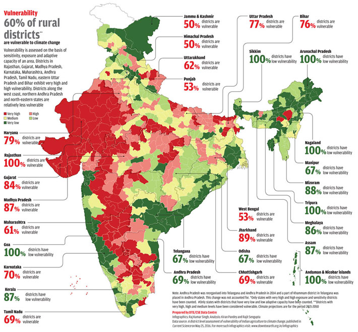
Note: Andhra Pradesh was reorganised into Telangana and Andhra Pradesh in 2014 and a part of Khammam district in Telangana was placed in Andhra Pradesh. This change was not accounted for.
*Only states with very high and high exposure and sensitivity districts have been counted.
#Only states with districts that have very low and low adaptive capacity have been counted.
**Districts with very high, high and medium levels have been considered vulnerable. Climate projections are for the period 2021-2050
Prepared by DTE/CSE Data Centre
Infographics: Raj Kumar Singh; Analysis: Kiran Pandey and Rajit Sengupta
Data source: A district level assessment of vulnerability of Indian agriculture to climate change, published in Current Science on May 25, 2016.
For more such infographics visit: www.downtoearth.org.in/infographics
We are a voice to you; you have been a support to us. Together we build journalism that is independent, credible and fearless. You can further help us by making a donation. This will mean a lot for our ability to bring you news, perspectives and analysis from the ground so that we can make change together.
India Environment Portal Resources :


.png)
Comments are moderated and will be published only after the site moderator’s approval. Please use a genuine email ID and provide your name. Selected comments may also be used in the ‘Letters’ section of the Down To Earth print edition.